The Comox District Mountaineering Club had a hike to Mt. Drabble on Forbidden Plateau today – taking an alternative access via logging roads from the north, rather than hiking in from the old Forbidden Plateau ski hill trailhead to the southeast.

Fall Colours on Drabble Ridge
The fall colours were spectacular: blueberries in shades of red; peach-coloured rhododendron; orange mountain-ash leaves; and clubrush & other grasses golden.

Fall Colours Reflections
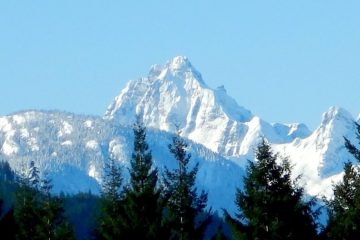
The clouds rose high enough for views of the peaks of Strathcona Park, including great views of the iconic Comox Glacier.

Comox Glacier from Mt. Drabble
Most features with ‘Mount’ preceding the name indicate the feature was named after a person, and Mt. Drabble is such a feature. As described on GeoBC, it was “Named after George Fawcett Drabble, CE, BCLS, an early settler who arrived in the Comox area around 1868, and in subsequent years occupied himself variously as store keeper, fur trader, magistrate and government agent. As an engineer and professional land surveyor, he surveyed many of the early pre-emptions and laid out the first roads in the Comox – Campbell River – Quadra Island area. His journals – consisting of 124 leatherbound notebooks covering the years 1865-1900, and originally bequeathed to Gordon Wagner BCLS – are now held in the Archives of the Campbell River and District Museum.”

Pond on Drabble Ridge
At about 1220 m elevation, the route enters Strathcona Park. We took 2-1/2 hrs to hike in (with many photo breaks) to Mt. Drabble; 3.5 km with a cumulative elevation gain of 350 m. The hike down was faster, (as always!) – about 1-1/2 hrs.
View Hike to Mt. Drabble in a larger map